
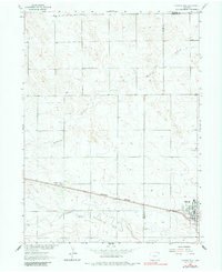
1962 Map of Haxtun West
USGS Topo · Published 1964About this map
The town of Haxtun serves as the primary hub of this 1960s agricultural and energy landscape, positioned at the edge of the Logan and Phillips County line. The settlement pattern is defined by the Chicago Burlington and Quincy railroad, which runs straight through the plains toward the smaller community of Dailey. This era represents a period of resource extraction on the High Plains, evidenced by the Dailey Oil Field and scattered infrastructure like the local Radio Tower. Local life is anchored by the High School and a communal Cemetery, while the natural drainage of the land is shaped by the winding paths of Wildhorse Creek and the North Fork Frenchman Creek. The map provides a clear look at the intersection of rail-based commerce and the emerging oil industry in northeastern Colorado.
Find a feature on this map
11 named features on this map. Tap any name to fly to it.
Don’t see what you’re looking for? This feature index may not catch every label — zoom into the map to look around manually.
Map Details
Editions of this 1962 Haxtun West Map
2 editions found
Other maps of this area

1952 · Marks Butte
USGS Topo · 1:24,000

1953 · Tamarack Ranch
USGS Topo · 1:24,000

1953 · Crook
USGS Topo · 1:24,000

1954 · Sterling
USGS Topo · 1:250,000

1958 · Sterling
USGS Topo · 1:250,000

1962 · Fleming
USGS Topo · 1:24,000

1962 · Haxtun East
USGS Topo · 1:24,000

1971 · Haxtun SE
USGS Topo · 1:24,000

1972 · St Petersburg
USGS Topo · 1:24,000

1972 · Rockland
USGS Topo · 1:24,000