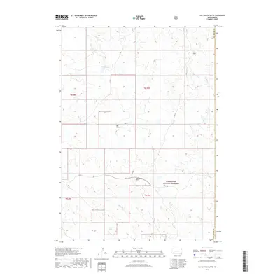
2017 Map of Hay Canyon Butte
USGS Topo · Published 2017About this map
Buffalo Gap National Grassland dominates the southern landscape of this quadrangle, where the high plains meet the intricate drainage systems of southwestern South Dakota. The prominent Hay Canyon Butte serves as a central landmark above the rugged incisions of Hay Canyon and the West Kneebone Draw. This 2017 survey details a sparsely populated ranching and grazing environment, where water management is critical to the local economy. Features such as Bockert Reservoir and the headwaters of Cedar Bluff Cr and Rock Butte Cr illustrate how the land is utilized. The White River Divide runs through the northern sections, marking the hydrologic boundary that shapes the terrain. Transport in the area is defined by established routes like Smithwick Rd and Co Hwy 1, which connect remote homesteads across the Fall River County line.
Find a feature on this map
18 named features on this map. Tap any name to fly to it.
Don’t see what you’re looking for? This feature index may not catch every label — zoom into the map to look around manually.
Map Details
Editions of this 2017 Hay Canyon Butte Map
This is the sole edition of this map. No revisions or reprints were ever made.
Other maps of this area

1896 · Oelrichs
USGS Topo · 1:125,000

1900 · Oelrichs
USGS Topo · 1:125,000

1951 · Willow Creek NW
USGS Topo · 1:24,000

1951 · Smithwick NE
USGS Topo · 1:24,000

1951 · Smithwick NW
USGS Topo · 1:24,000

1955 · Hot Springs
USGS Topo · 1:250,000

1967 · Slim Butte NW
USGS Topo · 1:24,000

1967 · Willow Creek SW
USGS Topo · 1:24,000
1982 · Smithwick
USGS Topo · 1:25,000
1982 · Hay Canyon Butte
USGS Topo · 1:25,000