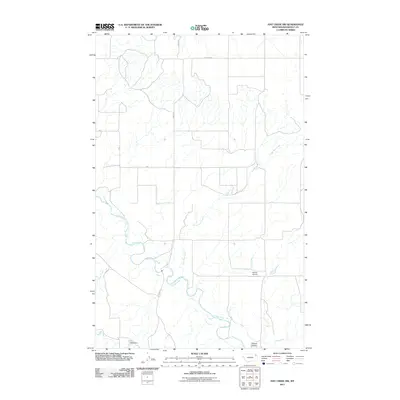
2011 Map of Hay Creek NW
USGS Topo · Published 2011About this map
Poplar River meanders through this portion of Roosevelt County, Montana, carving a complex path across a landscape defined by drainage systems and localized water management. The presence of Beck Dam in the south illustrates the area's agricultural reliance on harnessed water resources, while Swank Airport stands as a notable landmark near the topographic depression of Swank Coulee. The map details a network of vital seasonal waterways, including Lone Tree Creek, Short Creek, and Hay Creek, which dictate the local topography. This early 21st-century survey documents the rural infrastructure of the region, anchored by primary transit corridors such as River Rd and W Poplar Rd. These routes provide the framework for a sparsely settled landscape where geographical features and small-scale landmarks like the airport serve as the primary points of reference.
Find a feature on this map
9 named features on this map. Tap any name to fly to it.
Don’t see what you’re looking for? This feature index may not catch every label — zoom into the map to look around manually.
Map Details
Editions of this 2011 Hay Creek NW Map
This is the sole edition of this map. No revisions or reprints were ever made.
Other maps of this area

1910 · Cuskers
USGS Topo · 1:62,500

1912 · Hay Creek
USGS Topo · 1:62,500

1915 · Cuskers
USGS Topo · 1:62,500

1954 · Wolf Point
USGS Topo · 1:250,000

1958 · Wolf Point
USGS Topo · 1:250,000

1973 · Bredette
USGS Topo · 1:24,000

1973 · Pleasant Prairie
USGS Topo · 1:24,000

1973 · Pleasant Prairie SW
USGS Topo · 1:24,000
1983 · Hay Creek NW
USGS Topo · 1:24,000
1983 · Long Creek West
USGS Topo · 1:24,000