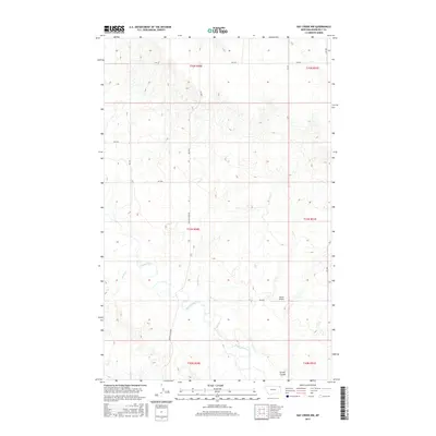
2017 Map of Hay Creek NW
USGS Topo · Published 2017About this map
Poplar River meanders through this section of Roosevelt County, carving a wide valley floor surrounded by the high plains of the Poplar District. The landscape is defined by the drainage patterns of seasonal tributaries like Lone Tree Cr and Short Cr, which feed into the main river channel from the surrounding uplands. Human activity in this rural Montana landscape is marked by a sparse network of section-line roads, such as Poplar River Rd and RD 2035, supporting the local ranching and agricultural operations. The inclusion of Swank Airport near Swank Coulee highlights the importance of light aircraft for transit and utility in these expansive, low-population areas where the distance between settlements remains a defining characteristic of daily life.
Find a feature on this map
21 named features on this map. Tap any name to fly to it.
Don’t see what you’re looking for? This feature index may not catch every label — zoom into the map to look around manually.
Map Details
Editions of this 2017 Hay Creek NW Map
This is the sole edition of this map. No revisions or reprints were ever made.
Other maps of this area

1910 · Cuskers
USGS Topo · 1:62,500

1912 · Hay Creek
USGS Topo · 1:62,500

1915 · Cuskers
USGS Topo · 1:62,500

1954 · Wolf Point
USGS Topo · 1:250,000

1958 · Wolf Point
USGS Topo · 1:250,000

1973 · Bredette
USGS Topo · 1:24,000

1973 · Pleasant Prairie
USGS Topo · 1:24,000

1973 · Pleasant Prairie SW
USGS Topo · 1:24,000
1983 · Hay Creek NW
USGS Topo · 1:24,000
1983 · Long Creek West
USGS Topo · 1:24,000