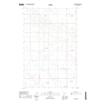
2020 Map of Hay Creek NW
USGS Topo · Published 2020About this map
Poplar River winds through the heart of this Roosevelt County landscape, defining the local drainage patterns and road networks that serve this portion of the Poplar District. The terrain is marked by significant hydrological features, including the junctions of Lone Tree Cr and Short Cr as they feed into the primary river valley. A notable center of activity in this otherwise rural expanse is Swank Airport, situated near the head of Swank Coulee. The map illustrates a developed grid of rural routes such as Poplar River Rd and various numbered roads like Rd 2041, which facilitate movement between the survey townships. This modern topographic study by the U.S. Geological Survey provides a precise view of the land use and accessibility in northeastern Montana, reflecting the continued importance of the river systems to the regional geography.
Find a feature on this map
21 named features on this map. Tap any name to fly to it.
Don’t see what you’re looking for? This feature index may not catch every label — zoom into the map to look around manually.
Map Details
Editions of this 2020 Hay Creek NW Map
This is the sole edition of this map. No revisions or reprints were ever made.
Other maps of this area

1910 · Cuskers
USGS Topo · 1:62,500

1912 · Hay Creek
USGS Topo · 1:62,500

1915 · Cuskers
USGS Topo · 1:62,500

1954 · Wolf Point
USGS Topo · 1:250,000

1958 · Wolf Point
USGS Topo · 1:250,000

1973 · Bredette
USGS Topo · 1:24,000

1973 · Pleasant Prairie
USGS Topo · 1:24,000

1973 · Pleasant Prairie SW
USGS Topo · 1:24,000
1983 · Hay Creek NW
USGS Topo · 1:24,000
1983 · Long Creek West
USGS Topo · 1:24,000