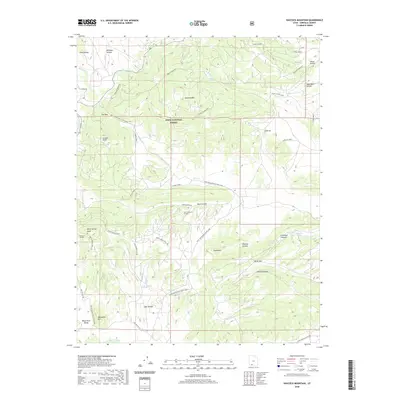
2020 Map of Haycock Mountain
USGS Topo · Published 2020About this map
Dixie National Forest dominates this high-altitude landscape in Garfield County, characterized by a complex network of drainages and volcanic or sedimentary heights. Significant landmarks include the massive Haycock Mountain and the prominent Birch Spring Knoll, surrounded by numerous named hollows such as Mexican Hollow and Sage Hen Hollow. The map reveals a specific focus on water resources in this arid upland, documented through sites like Cameron Troughs and John Cameron Troughs, which suggest a history of livestock management and range use. Natural springs like Limerock Spring and Lake Hollow Spring serve as critical points in the terrain, while the shoreline of Panguitch Lake appears in the northwest corner. A extensive loop system, including the Birch-Spring-Pass Creek Loop, provides access through the rugged canyons and across high points like The Pass, reflecting the area's recreational and forest management infrastructure.
Find a feature on this map
51 named features on this map. Tap any name to fly to it.
Don’t see what you’re looking for? This feature index may not catch every label — zoom into the map to look around manually.
Map Details
Editions of this 2020 Haycock Mountain Map
This is the sole edition of this map. No revisions or reprints were ever made.
Other maps of this area

1886 · Kanab
USGS Topo · 1:250,000

1953 · Cedar City
USGS Topo · 1:250,000

1958 · Cedar City
USGS Topo · 1:250,000

1958 · Panguitch Lake
USGS Topo · 1:62,500

1962 · Cedar City
USGS Topo · 1:250,000

1966 · Hatch
USGS Topo · 1:24,000

1966 · George Mtn
USGS Topo · 1:24,000

1971 · Fivemile Ridge
USGS Topo · 1:24,000
1971 · Panguitch
USGS Topo · 1:24,000
1971 · Red Creek Reservoir
USGS Topo · 1:24,000