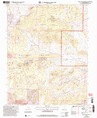
2002 Map of Haycock Mountain
USGS Topo · Published 2005About this map
The Dixie National Forest defines this high-plateau landscape in Garfield County, dominated by the prominent peaks of Haycock Mountain and Hatch Mountain. The 2002 revision by the U.S. Department of Agriculture illustrates a terrain shaped by volcanic activity and water, where the southern edge gives way to Black Rock Valley and its distinct Lava flows. Notable water features such as Panguitch Lake and Mammoth Creek are critical landmarks in this arid environment, while a remote Landing Strip suggests the logistical needs of modern forest management and fire control.
Find a feature on this map
49 named features on this map. Tap any name to fly to it.
Don’t see what you’re looking for? This feature index may not catch every label — zoom into the map to look around manually.
Map Details
Editions of this 2002 Haycock Mountain Map
This is the sole edition of this map. No revisions or reprints were ever made.
Other maps of this area

1886 · Kanab
USGS Topo · 1:250,000

1953 · Cedar City
USGS Topo · 1:250,000

1958 · Cedar City
USGS Topo · 1:250,000

1958 · Panguitch Lake
USGS Topo · 1:62,500

1962 · Cedar City
USGS Topo · 1:250,000

1966 · Hatch
USGS Topo · 1:24,000

1966 · George Mtn
USGS Topo · 1:24,000

1971 · Fivemile Ridge
USGS Topo · 1:24,000
1971 · Panguitch
USGS Topo · 1:24,000
1971 · Red Creek Reservoir
USGS Topo · 1:24,000