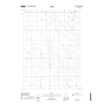
2017 Map of Hayes South
USGS Topo · Published 2017About this map
The small community of Hayes serves as the focal point for this expansive section of Stanley County, located at the intersection of Hayes Rd and Rolling Green Pl. This high-plains landscape is defined by its drainage systems, where seasonal watercourses like Wagonhound Cr and Plum Cr carve subtle relief into the terrain. The presence of the Hayes Emergency Airstrip and Hayes Lake near the town center highlights the area's role as a regional hub for aviation safety and local water resources. To the east and south, the terrain rises to notable high points such as Lookout Point and Round Top, offering a clear view of the surrounding prairie. The map details a strictly organized grid of rural routes including 212th St and S Brown Rd, which facilitate movement between the various townships that segment this agricultural and grazing land.
Find a feature on this map
26 named features on this map. Tap any name to fly to it.
Don’t see what you’re looking for? This feature index may not catch every label — zoom into the map to look around manually.
Map Details
Editions of this 2017 Hayes South Map
This is the sole edition of this map. No revisions or reprints were ever made.
Other maps of this area

1951 · Capa NW
USGS Topo · 1:24,000

1954 · Pierre
USGS Topo · 1:250,000

1958 · Pierre
USGS Topo · 1:250,000

1980 · Princes Ranch
USGS Topo · 1:25,000

1982 · Hayes South
USGS Topo · 1:24,000

1982 · Hohrman Ranch
USGS Topo · 1:24,000
1982 · Midland NE
USGS Topo · 1:24,000

1982 · Midland NW
USGS Topo · 1:24,000

1982 · May Ranch
USGS Topo · 1:24,000

1983 · Bentley Ranch
USGS Topo · 1:24,000