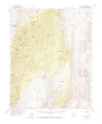
1960 Map of Hayford Peak
USGS Topo · Published 1972About this map
Hayford Peak and the high ridges of the Sheep Range dominate this 1960 survey of southern Nevada's arid interior. The landscape is defined by its water sources, with vital points like Mormon Well, Bootleg Spring, and Quijinump Spring serving as the only relief in the surrounding Desert Range. Human presence is sparse, centered on small outposts such as Hidden Forest Cabin and Pine Nut Camp which sit at the edges of the Yucca Forest.
Find a feature on this map
49 named features on this map. Tap any name to fly to it.
Don’t see what you’re looking for? This feature index may not catch every label — zoom into the map to look around manually.
Map Details
Editions of this 1960 Hayford Peak Map
2 editions found

Other maps of this area

1886 · Saint Thomas
USGS Topo · 1:250,000

1893 · Saint Thomas
USGS Topo · 1:250,000

1907 · Las Vegas
USGS Topo · 1:250,000

1908 · Las Vegas
USGS Topo · 1:250,000

1926 · Boulder Canyon
USGS Topo · 1:96,000

1945 · Sheep Range
USGS Topo · 1:125,000

1952 · Corn Creek Springs
USGS Topo · 1:62,500

1952 · Gass Peak
USGS Topo · 1:62,500

1952 · Dry Lake
USGS Topo · 1:62,500

1954 · Las Vegas
USGS Topo · 1:250,000