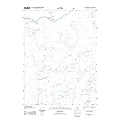
2012 Map of Hayfork Bally
USGS Topo · Published 2012About this map
Trinity River flows across the northern reaches of this Trinity County landscape, a vital corridor anchored by public spaces like Big Flat Campground and the Skunk Point Picnic Area. The terrain rises sharply away from the water towards the southern peaks, dominated by the high vantage of Hayfork Bally and its associated Hayfork Bally Lookout. This 2012 survey illustrates the network of Forest Service routes, such as Forest Rte 16 and Forest Rte 33N52, which provide access to isolated private holdings like Rose Ranch and Eagle Ranch.
Find a feature on this map
79 named features on this map. Tap any name to fly to it.
Don’t see what you’re looking for? This feature index may not catch every label — zoom into the map to look around manually.
Map Details
Editions of this 2012 Hayfork Bally Map
This is the sole edition of this map. No revisions or reprints were ever made.
Other maps of this area

1909 · Big Bar
USGS Topo · 1:96,000

1915 · Big Bar and Vicinity
USGS Topo · 1:250,000

1951 · Hayfork
USGS Topo · 1:62,500

1951 · Helena
USGS Topo · 1:62,500

1951 · Hyampom
USGS Topo · 1:62,500

1951 · Ironside Mountain
USGS Topo · 1:62,500

1958 · Redding
USGS Topo · 1:250,000

1982 · Helena
USGS Topo · 1:24,000
1982 · Big Bar
USGS Topo · 1:24,000
1982 · Hayfork Bally
USGS Topo · 1:24,000