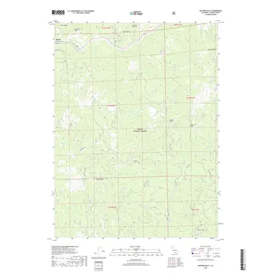
2018 Map of Hayfork Bally
USGS Topo · Published 2018About this map
Big Bar sits at the northern edge of this terrain, where the Trinity River cuts through the steep slopes of the Salmon Mountains. This mountainous region within the Trinity National Forest is defined by a series of prominent high points and drainage systems, including the namesake peak of Hayfork Bally and the sweeping Hayfork Divide. The landscape is etched with numerous creeks and springs, such as Love Letter Spring and Squaw Camp Spring, which historically supported the hydraulic needs of early mining and transit through these remote corridors. Access across the ridges is dictated by a network of forest routes, including Manzanita Ridge Rd and Big Creek Rd, tracing the same steep grades used for generations to traverse between the river and the inland valleys.
Find a feature on this map
45 named features on this map. Tap any name to fly to it.
Don’t see what you’re looking for? This feature index may not catch every label — zoom into the map to look around manually.
Map Details
Editions of this 2018 Hayfork Bally Map
This is the sole edition of this map. No revisions or reprints were ever made.
Other maps of this area

1909 · Big Bar
USGS Topo · 1:96,000

1915 · Big Bar and Vicinity
USGS Topo · 1:250,000

1951 · Hayfork
USGS Topo · 1:62,500

1951 · Helena
USGS Topo · 1:62,500

1951 · Hyampom
USGS Topo · 1:62,500

1951 · Ironside Mountain
USGS Topo · 1:62,500

1958 · Redding
USGS Topo · 1:250,000

1982 · Helena
USGS Topo · 1:24,000
1982 · Big Bar
USGS Topo · 1:24,000
1982 · Hayfork Bally
USGS Topo · 1:24,000