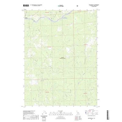
2021 Map of Hayfork Bally
USGS Topo · Published 2021About this map
The Trinity Wild and Scenic River carves through the northern reaches of this Trinity County landscape, marking a deep drainage near the settlement of Big Bar. This 2021 survey highlights the complex topography of the Trinity National Forest, where high elevations like Hayfork Bally overlook a series of prominent divides including Manzanita Ridge and Limestone Ridge. The terrain is defined by its water sources, from the curiously named Love Letter Spring to major tributaries such as Big Creek and Miners Creek. Cultural traces are sparse but significant, including the historic site of Rose Ranch and a network of forest roads like Packers Creek and Soldier ID that provide access to the Salmon Mountains interior. This map is a primary resource for understanding the contemporary drainage patterns and named landmarks within this protected wilderness area.
Find a feature on this map
41 named features on this map. Tap any name to fly to it.
Don’t see what you’re looking for? This feature index may not catch every label — zoom into the map to look around manually.
Map Details
Editions of this 2021 Hayfork Bally Map
This is the sole edition of this map. No revisions or reprints were ever made.
Other maps of this area

1909 · Big Bar
USGS Topo · 1:96,000

1915 · Big Bar and Vicinity
USGS Topo · 1:250,000

1951 · Hayfork
USGS Topo · 1:62,500

1951 · Helena
USGS Topo · 1:62,500

1951 · Hyampom
USGS Topo · 1:62,500

1951 · Ironside Mountain
USGS Topo · 1:62,500

1958 · Redding
USGS Topo · 1:250,000

1982 · Helena
USGS Topo · 1:24,000
1982 · Big Bar
USGS Topo · 1:24,000
1982 · Hayfork Bally
USGS Topo · 1:24,000