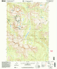
2000 Map of Haystack Peak
USGS Topo · Published 2005About this map
Independence (Site) sits deep within the high-elevation terrain where the Park and Sweet Grass county line traverses the peaks. This 2000 revision reveals the remnants of historic mining activity, most notably at the Independence Mine, which is surrounded by labels for Prospects and Tailings. The landscape is dominated by the steep drainages of the East Fork Boulder River and Bull Creek, with several alpine water bodies such as Lake Kathleen and Blue Lake marking the glacial basins. Significant peaks like Haystack Peak, Baboon Mountain, and Monument Peak anchor the topography of the Absaroka-Beartooth Wilderness, showing a remote region primarily accessible via trails and four-wheel-drive routes like the Big Timber Gardiner path.
Find a feature on this map
36 named features on this map. Tap any name to fly to it.
Don’t see what you’re looking for? This feature index may not catch every label — zoom into the map to look around manually.
Map Details
Editions of this 2000 Haystack Peak Map
This is the sole edition of this map. No revisions or reprints were ever made.
Other maps of this area

1891 · Livingston
USGS Topo · 1:250,000

1893 · Livingston
USGS Topo · 1:250,000

1940 · Mt. Cowen
USGS Topo · 1:62,500

1940 · Mt Wallace
USGS Topo · 1:62,500

1941 · Mt Douglas
USGS Topo · 1:62,500

1942 · Cutoff Mtn
USGS Topo · 1:62,500

1943 · Mt Wallace
USGS Topo · 1:62,500

1943 · Mt Douglas
USGS Topo · 1:62,500

1943 · Mt Cowen
USGS Topo · 1:62,500

1944 · Cutoff Mtn
USGS Topo · 1:62,500