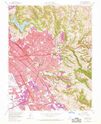
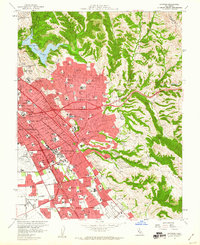
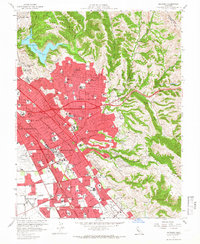
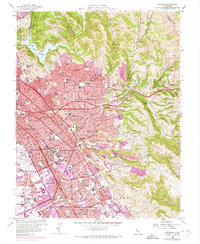
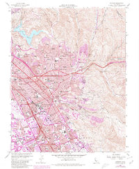
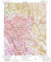
1959 Map of Hayward
USGS Topo · Published 1969About this map
The San Leandro Hills descend into a rapidly densifying East Bay corridor, where post-war suburban growth meets the established industrial and transport infrastructure of Hayward. This 1959 survey, updated with 1968 aerial data, shows the expansion of residential tracts across San Lorenzo and Castro Valley, reaching toward the foothills and Cull Canyon. The footprint of major institutions like California State College Hayward and the Alameda Co Juvenile Hall signal the area's increasing importance as an administrative and educational hub for Alameda County.
Find a feature on this map
89 named features on this map. Tap any name to fly to it.
Don’t see what you’re looking for? This feature index may not catch every label — zoom into the map to look around manually.
Map Details
Editions of this 1959 Hayward Map
6 editions found
Other maps of this area

1896 · Mt. Diablo
USGS Topo · 1:62,500

1897 · Concord
USGS Topo · 1:62,500

1898 · Mt. Diablo
USGS Topo · 1:62,500

1899 · Haywards
USGS Topo · 1:62,500

1906 · Pleasanton
USGS Topo · 1:62,500

1915 · Haywards
USGS Topo · 1:62,500

1915 · Concord
USGS Topo · 1:62,500

1941 · Pleasanton
USGS Topo · 1:62,500

1942 · Concord
USGS Topo · 1:62,500

1942 · Hayward
USGS Topo · 1:62,500