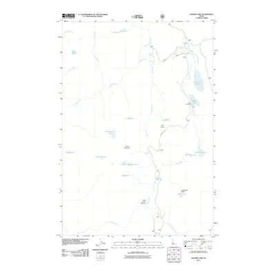
2011 Map of Hazard Lake
USGS Topo · Published 2011About this map
The Grass Mountains dominate this high-elevation landscape, where a dense concentration of glacial lakes and mountain streams forms the headwaters of the regional drainage system. The map showcases a recreation-focused geography, centered on the Hazard Lake Campground and the access provided by Hazard Lake Rd. This road serves as the primary artery for reaching landmarks like the Lloyds Lake Overlook, which provides vantage points over the numerous alpine water bodies such as Lake Serene and Big Hazard Lake.
Find a feature on this map
31 named features on this map. Tap any name to fly to it.
Don’t see what you’re looking for? This feature index may not catch every label — zoom into the map to look around manually.
Map Details
Editions of this 2011 Hazard Lake Map
This is the sole edition of this map. No revisions or reprints were ever made.
Other maps of this area

1938 · Riggins
USGS Topo · 1:96,000

1945 · Riggins
USGS Topo · 1:125,000

1955 · Grangeville
USGS Topo · 1:250,000

1959 · Grangeville
USGS Topo · 1:250,000

1963 · Bally Mountain
USGS Topo · 1:24,000

1963 · Indian Mountain
USGS Topo · 1:24,000

1963 · Granite Lake
USGS Topo · 1:24,000

1963 · Black Tip
USGS Topo · 1:24,000

1963 · Hershey Point
USGS Topo · 1:24,000
1963 · Hazard Lake
USGS Topo · 1:24,000