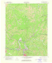
1972 Map of Hazard North
USGS Topo · Published 1973About this map
The Kentucky River and its North Fork anchor this portrait of the Appalachian coal country during a period of intensive industrial activity. Extensive Strip Mines dominate the ridgelines above narrow hollows, where company towns and coal camps like Blue Diamond, Harveyton, and Hardburly are tightly integrated with the Louisville and Nashville railroad network. The map captures the dense social fabric of the mountains through numerous family-named cemeteries and landmarks like the Hunter Memorial Ch and New Mt Zion Ch. Near the southern bend of the river, the development of Airport Gardens and the Hazard Airport signals the mid-century modernization of the region's infrastructure, even as traditional settlements like Dwarf and Ary persist along Troublesome Creek and Lotts Creek.
Find a feature on this map
75 named features on this map. Tap any name to fly to it.
Don’t see what you’re looking for? This feature index may not catch every label — zoom into the map to look around manually.
Map Details
Editions of this 1972 Hazard North Map
2 editions found
Other maps of this area

1891 · Hazard
USGS Topo · 1:125,000

1913 · Buckhorn
USGS Topo · 1:62,500

1914 · Troublesome
USGS Topo · 1:62,500

1916 · Cornettsville
USGS Topo · 1:62,500

1916 · Hyden
USGS Topo · 1:48,000

1919 · Hyden
USGS Topo · 1:62,500

1954 · Noble
USGS Topo · 1:24,000

1954 · Krypton
USGS Topo · 1:24,000
1954 · Hyden East
USGS Topo · 1:24,000
1954 · Haddix
USGS Topo · 1:24,000