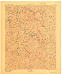
1891 Map of Hazard
USGS Topo · Published 1906About this map
Hazard serves as the focal point of this late 19th-century reconnaissance, situated at the confluence of several critical waterways within the Cumberland Plateau. The landscape is defined by an intricate network of narrow hollows and high ridges, where settlements like Hyden and Crockettsville developed along the winding paths of the Middle Fork and Troublesome Creek. This survey, conducted by E.C. Barnard and overseen by J.W. Powell, illustrates the primary reliance on natural water gaps for movement between isolated mountain communities. Notable landmarks like Nailors Rock and Lost Mt. rise above a labyrinth of forks and branches, including Buckhorn Creek and Quicksand Creek. The distribution of small settlements such as Viper, Dwarf, and Chavies reflects the early habitation patterns of Perry and Leslie counties before the arrival of large-scale industrial infrastructure.
Find a feature on this map
89 named features on this map. Tap any name to fly to it.
Don’t see what you’re looking for? This feature index may not catch every label — zoom into the map to look around manually.
Map Details
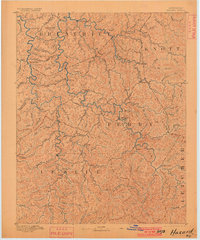
Editions of this 1891 Hazard Map
5 editions found
Other maps of this area

1886 · Prestonsburg
USGS Topo · 1:125,000

1886 · Cumberland Gap
USGS Topo · 1:125,000

1887 · Jonesville
USGS Topo · 1:125,000

1888 · Cumberland Gap
USGS Topo · 1:125,000

1889 · Salyersville
USGS Topo · 1:125,000

1890 · Whitesburg
USGS Topo · 1:125,000

1891 · Manchester
USGS Topo · 1:125,000

1891 · Cumberland Gap
USGS Topo · 1:125,000

1891 · Hazard
USGS Topo · 1:125,000

1891 · Jonesville
USGS Topo · 1:125,000