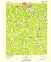
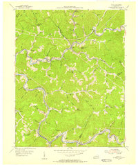
1954 Map of Hazard South
USGS Topo · Published 1956About this map
The Kentucky River North Fork serves as the industrial spine for this region of Perry County, its banks lined with coal-focused settlements and the tracks of the L & N RR. This mid-century survey captures the density of rural infrastructure typical of the Eastern Kentucky coalfields, where narrow hollows dictate the placement of communities like Glomawr, Lothair, and Diablock. The presence of numerous strip mines and gas wells throughout the uplands illustrates the intensive resource extraction that shaped the local economy and landscape during this era.
Find a feature on this map
85 named features on this map. Tap any name to fly to it.
Don’t see what you’re looking for? This feature index may not catch every label — zoom into the map to look around manually.
Map Details
Editions of this 1954 Hazard South Map
2 editions found
Other maps of this area

1891 · Hazard
USGS Topo · 1:125,000

1913 · Buckhorn
USGS Topo · 1:62,500

1914 · Troublesome
USGS Topo · 1:62,500

1916 · Cornettsville
USGS Topo · 1:62,500

1916 · Hyden
USGS Topo · 1:48,000

1919 · Hyden
USGS Topo · 1:62,500

1954 · Krypton
USGS Topo · 1:24,000
1954 · Hyden East
USGS Topo · 1:24,000
1954 · Tilford
USGS Topo · 1:24,000
1954 · Vicco
USGS Topo · 1:24,000