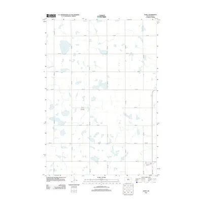
2012 Map of Hazel
USGS Topo · Published 2012About this map
The prairie landscape of South Dakota is defined by a grid of agricultural section lines and localized depressions in the 2012 Hazel area. The largest of these water bodies, Lake Henry, anchors the northwestern portion of the map, surrounded by numerous unnamed seasonal wetlands characteristic of the region’s glacial topography. This portion of Codington County is primarily organized around long stretches of gravel roads such as 437th Ave and 177th St. Social and historical nodes are sparse but significant, centered on sites like Our Saviors Church Cem and the Hazel Cem further south. These landmarks serve as the primary markers of settlement and community history within the vast, open fields, providing essential points of reference for genealogists and local historians tracking early family plots and church congregations in the township.
Find a feature on this map
22 named features on this map. Tap any name to fly to it.
Don’t see what you’re looking for? This feature index may not catch every label — zoom into the map to look around manually.
Map Details
Editions of this 2012 Hazel Map
This is the sole edition of this map. No revisions or reprints were ever made.
Other maps of this area

1953 · Watertown
USGS Topo · 1:250,000

1958 · Watertown
USGS Topo · 1:250,000

1973 · Garden City
USGS Topo · 1:24,000
1973 · Henry
USGS Topo · 1:24,000

1973 · Bryant NE
USGS Topo · 1:24,000

1973 · Vienna West
USGS Topo · 1:24,000
1973 · Kampeska
USGS Topo · 1:24,000

1973 · Naples
USGS Topo · 1:24,000
1973 · Grover
USGS Topo · 1:24,000

1973 · Vienna East
USGS Topo · 1:24,000