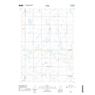
2017 Map of Hazel
USGS Topo · Published 2017About this map
Henry sits at the northern edge of this high prairie landscape, marking a transition point on the glacial highland known as the Coteau des Prairies. This 2017 survey reveals a deeply patterned agricultural grid defined by a dense network of numbered roads like 436th Ave and 175th St. The terrain is characterized by numerous small prairie potholes and wetlands, with Lake Henry serving as a significant water feature in the northwest corner. To the southeast, the small community of Hazel is detailed with its own local street plan, including Lafayette St and William St. This map is particularly useful for local historians tracking the intersection of three counties — Clark, Codington, and Hamlin — which meet amidst the section lines. Genealogical interest is centered on the rural Our Saviors Church Cem and the Hazel Cem, which remain as anchored landmarks within the vast farming blocks of the coteau.
Find a feature on this map
39 named features on this map. Tap any name to fly to it.
Don’t see what you’re looking for? This feature index may not catch every label — zoom into the map to look around manually.
Map Details
Editions of this 2017 Hazel Map
This is the sole edition of this map. No revisions or reprints were ever made.
Other maps of this area

1953 · Watertown
USGS Topo · 1:250,000

1958 · Watertown
USGS Topo · 1:250,000

1973 · Garden City
USGS Topo · 1:24,000
1973 · Henry
USGS Topo · 1:24,000

1973 · Bryant NE
USGS Topo · 1:24,000

1973 · Vienna West
USGS Topo · 1:24,000
1973 · Kampeska
USGS Topo · 1:24,000

1973 · Naples
USGS Topo · 1:24,000
1973 · Grover
USGS Topo · 1:24,000

1973 · Vienna East
USGS Topo · 1:24,000