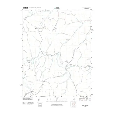
2010 Map of Hazel Green
USGS Topo · Published 2010About this map
Maytown and Daysboro anchor a landscape defined by the winding course of the Red River and its numerous mountain tributaries in Wolfe and Morgan Counties. The region is characterized by a high concentration of family-named landmarks and historical crossing points, including Flat Rock Ford and Clarks Ford. Genealogists will find a wealth of specific sites such as Flat Rock Cemetery, Peiratt Cemetery, and Murphy Fork Cemetery scattered among the many named branches and forks. Small settlements like Toliver, Murphyfork, and Stillwater are connected by a network of local roads that follow the tight valley floors. The mapping of Gibbs Hollow and the numerous smaller drainages like Lackey Creek and Caskey Fork illustrates the deeply dissected terrain of the Cumberland Plateau, where every hollow and ridge line carries a specific local name.
Find a feature on this map
72 named features on this map. Tap any name to fly to it.
Don’t see what you’re looking for? This feature index may not catch every label — zoom into the map to look around manually.
Map Details
Editions of this 2010 Hazel Green Map
This is the sole edition of this map. No revisions or reprints were ever made.
Other maps of this area

1889 · Salyersville
USGS Topo · 1:125,000

1891 · Salyersville
USGS Topo · 1:125,000

1892 · Beattyville
USGS Topo · 1:125,000

1899 · Salyersville
USGS Topo · 1:125,000

1951 · Cannel City
USGS Topo · 1:24,000

1951 · Landsaw
USGS Topo · 1:24,000

1951 · Ezel
USGS Topo · 1:24,000

1951 · Hazel Green
USGS Topo · 1:24,000

1951 · Pomeroyton
USGS Topo · 1:24,000
1951 · West Liberty
USGS Topo · 1:24,000