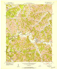
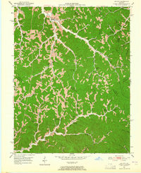
1951 Map of Hazel Green
USGS Topo · Published 1953About this map
Hazel Green serves as the primary hub of this 1951 topographic study, situated along the meandering course of the Red River. The landscape is defined by the steep, narrow valleys of the Cumberland Plateau, where settlement patterns strictly follow the drainage of the Stillwater Creek and Blackwater Creek systems. Educational and religious life in these rural communities is anchored by landmarks like the Hazel Green Academy and several family-named schools such as Rankin-Mize Sch and Sandfield Sch.
Find a feature on this map
47 named features on this map. Tap any name to fly to it.
Don’t see what you’re looking for? This feature index may not catch every label — zoom into the map to look around manually.
Map Details
Editions of this 1951 Hazel Green Map
This is the sole edition of this map. No revisions or reprints were ever made.
Other maps of this area

1889 · Salyersville
USGS Topo · 1:125,000

1891 · Salyersville
USGS Topo · 1:125,000
1892 · Beattyville
USGS Topo · 1:125,000
1899 · Salyersville
USGS Topo · 1:125,000
1951 · Cannel City
USGS Topo · 1:24,000
1951 · Landsaw
USGS Topo · 1:24,000
1951 · Ezel
USGS Topo · 1:24,000
1951 · Pomeroyton
USGS Topo · 1:24,000
1951 · West Liberty
USGS Topo · 1:24,000
1951 · Lee City
USGS Topo · 1:24,000