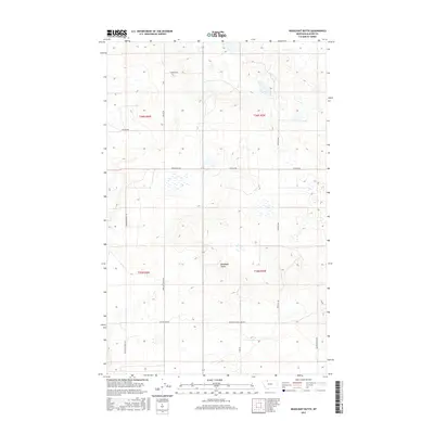
2017 Map of Headlight Butte
USGS Topo · Published 2017About this map
Headlight Butte rises as the central landmark in this expanse of Glacier County, Montana, where a network of rural roads defines the movement of local ranching and power infrastructure. The landscape is marked by the presence of family and settlement-named thoroughfares such as Winkler School Rd and Zenith Rd, which anchor the area's social geography. To the south, industrial and residential legacies are suggested by Montana Power Camp Rd and Carter Camp Rd, pointing to the region's connection to regional energy development. This 2017 survey illustrates a high-plains topography where traditional property lines, defined by township and range boundaries like t36n r6w, intersect with modern service roads. Local history researchers can trace the connectivity between remote outposts via named routes like Proefrock Rd and Tipville Rd in a region where the vastness is measured by the distance between these distinct intersections.
Find a feature on this map
16 named features on this map. Tap any name to fly to it.
Don’t see what you’re looking for? This feature index may not catch every label — zoom into the map to look around manually.
Map Details
Editions of this 2017 Headlight Butte Map
This is the sole edition of this map. No revisions or reprints were ever made.
Other maps of this area

1907 · Blackfoot Res.
USGS Topo · 1:48,000

1909 · Cut Bank
USGS Topo · 1:125,000

1912 · Cut Bank
USGS Topo · 1:125,000

1960 · Cut Bank
USGS Topo · 1:250,000

1963 · Cut Bank
USGS Topo · 1:250,000

1964 · Cut Bank
USGS Topo · 1:250,000

1966 · Ethridge NW
USGS Topo · 1:24,000
1966 · Cut Bank
USGS Topo · 1:24,000
1966 · Gunsight
USGS Topo · 1:24,000

1968 · Headlight Butte NE
USGS Topo · 1:24,000