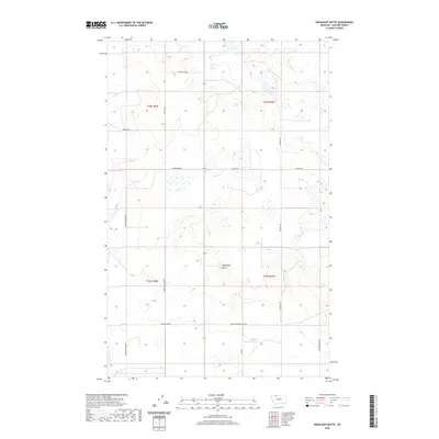
2020 Map of Headlight Butte
USGS Topo · Published 2020About this map
Headlight Butte rises as the primary topographic landmark in this section of Glacier County, situated within a high-plains landscape defined by section-line roads and seasonal wetlands. The map details a rural infrastructure rooted in ranching and energy, evidenced by corridors like Montana Power Camp Rd and Carter Camp Rd. The local road network reveals long-standing communal and educational ties, with Winkler School Rd and Zenith Rd providing access to remote properties and the nearby Hutterite colony. Navigating the terrain between T36N and T35N, the survey captures the sparse but organized settlement pattern of the Montana plains, where names like Tipville Rd and Micheals Rd mark the routes connecting isolated farmsteads across the wide open spaces of the northern front.
Find a feature on this map
16 named features on this map. Tap any name to fly to it.
Don’t see what you’re looking for? This feature index may not catch every label — zoom into the map to look around manually.
Map Details
Editions of this 2020 Headlight Butte Map
This is the sole edition of this map. No revisions or reprints were ever made.
Other maps of this area

1907 · Blackfoot Res.
USGS Topo · 1:48,000

1909 · Cut Bank
USGS Topo · 1:125,000

1912 · Cut Bank
USGS Topo · 1:125,000

1960 · Cut Bank
USGS Topo · 1:250,000

1963 · Cut Bank
USGS Topo · 1:250,000

1964 · Cut Bank
USGS Topo · 1:250,000

1966 · Ethridge NW
USGS Topo · 1:24,000
1966 · Cut Bank
USGS Topo · 1:24,000
1966 · Gunsight
USGS Topo · 1:24,000

1968 · Headlight Butte NE
USGS Topo · 1:24,000