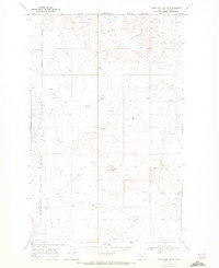
1968 Map of Headlight Butte
USGS Topo · Published 1972About this map
The Blackfeet Indian Reservation Boundary runs through the western edge of this 1960s landscape, marking a clear divide in land use and ownership in Glacier County. This region is defined by its extensive energy infrastructure, specifically the development of an Oil Field that spans across the prairie. The topography is dominated by the prominent elevation of Headlight Butte, which serves as a central landmark for the area. Scattered across the grid of section lines are numerous Oil Wells, Gas Wells, and supporting facilities like a Pumping Sta and a Radio Tower. In the southern portion of the sheet, Whetstone Camp sits near a Substa, providing a rare point of named habitation amidst the industrial network of a Pipeline and access roads that crisscross the plains.
Find a feature on this map
14 named features on this map. Tap any name to fly to it.
Don’t see what you’re looking for? This feature index may not catch every label — zoom into the map to look around manually.
Map Details
Editions of this 1968 Headlight Butte Map
This is the sole edition of this map. No revisions or reprints were ever made.
Other maps of this area

1907 · Blackfoot Res.
USGS Topo · 1:48,000

1909 · Cut Bank
USGS Topo · 1:125,000

1912 · Cut Bank
USGS Topo · 1:125,000

1960 · Cut Bank
USGS Topo · 1:250,000

1963 · Cut Bank
USGS Topo · 1:250,000

1964 · Cut Bank
USGS Topo · 1:250,000

1966 · Ethridge NW
USGS Topo · 1:24,000
1966 · Cut Bank
USGS Topo · 1:24,000
1966 · Gunsight
USGS Topo · 1:24,000

1968 · Headlight Butte NE
USGS Topo · 1:24,000