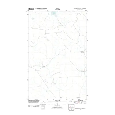
2011 Map of Headlight Butte NW
USGS Topo · Published 2011About this map
Boundary Lake anchors the northern edge of this high plains landscape along the international border in Glacier County. The terrain is defined by a network of drainage channels and intermittent watercourses, most notably the winding paths of Big Rock Coulee and the East Fork Big Rock Coulee. This 2011 survey illustrates a sparse ranching or agricultural environment where infrastructure is limited to essential water management and access roads. A key man-made landmark is the Marathon Dam, which controls local water flow in an otherwise arid region. Grounded by Altenburg Rd, the map provides a clear look at the rural grid system and land use patterns of north-central Montana in the early 21st century.
Find a feature on this map
5 named features on this map. Tap any name to fly to it.
Don’t see what you’re looking for? This feature index may not catch every label — zoom into the map to look around manually.
Map Details
Editions of this 2011 Headlight Butte NW Map
This is the sole edition of this map. No revisions or reprints were ever made.
Other maps of this area

1909 · Cut Bank
USGS Topo · 1:125,000

1911 · Blackfoot
USGS Topo · 1:125,000

1912 · Cut Bank
USGS Topo · 1:125,000

1960 · Cut Bank
USGS Topo · 1:250,000

1963 · Cut Bank
USGS Topo · 1:250,000

1964 · Cut Bank
USGS Topo · 1:250,000

1968 · Headlight Butte NE
USGS Topo · 1:24,000
1968 · Dead Indian Spring
USGS Topo · 1:24,000
1968 · Love Rock
USGS Topo · 1:24,000

1968 · Rocky Buttes
USGS Topo · 1:24,000