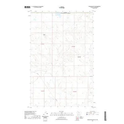
2020 Map of Headlight Butte NW
USGS Topo · Published 2020About this map
Boundary Lake sits directly on the international border on this high-plains Montana landscape, where the northern limit of Glacier County meets the Canadian frontier. The terrain is defined by the deep incisions of Big Rock Coulee and its East Fork Big Rock Coulee, which snake across the township sections of T37N and T36N. This modern survey illustrates the sparse, open character of the borderlands, where human presence is largely limited to the section-line grids and isolated routes like Reagan Rd and Altenberg Rd. The map provides a clear record of contemporary land divisions and topographical drainage patterns in a remote region where the high prairie begins to dip toward the northern water systems.
Find a feature on this map
10 named features on this map. Tap any name to fly to it.
Don’t see what you’re looking for? This feature index may not catch every label — zoom into the map to look around manually.
Map Details
Editions of this 2020 Headlight Butte NW Map
This is the sole edition of this map. No revisions or reprints were ever made.
Other maps of this area

1909 · Cut Bank
USGS Topo · 1:125,000

1911 · Blackfoot
USGS Topo · 1:125,000

1912 · Cut Bank
USGS Topo · 1:125,000

1960 · Cut Bank
USGS Topo · 1:250,000

1963 · Cut Bank
USGS Topo · 1:250,000

1964 · Cut Bank
USGS Topo · 1:250,000

1968 · Headlight Butte NE
USGS Topo · 1:24,000
1968 · Dead Indian Spring
USGS Topo · 1:24,000
1968 · Love Rock
USGS Topo · 1:24,000

1968 · Rocky Buttes
USGS Topo · 1:24,000