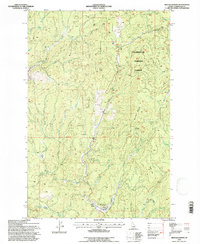
1994 Map of Headquarters
USGS Topo · Published 1997About this map
Headquarters stands as the central hub of activity in this section of the Clearwater National Forest during the mid-1990s. The landscape is defined by its industrial and recreational history, evidenced by the Old Railroad Grade winding through the timbered slopes and the established Harley Creek Scout Camp south of the main settlement. The presence of Old Camp and Old Camp 6 along the northern drainages reflects earlier phases of logging operations that shaped these mountains.
Find a feature on this map
33 named features on this map. Tap any name to fly to it.
Don’t see what you’re looking for? This feature index may not catch every label — zoom into the map to look around manually.
Map Details
Editions of this 1994 Headquarters Map
This is the sole edition of this map. No revisions or reprints were ever made.
Other maps of this area

1923 · Washington Creek
USGS Topo · 1:125,000

1936 · Boehls Butte
USGS Topo · 1:48,000

1938 · Headquarters
USGS Topo · 1:48,000

1943 · Boehls Butte
USGS Topo · 1:62,500

1944 · Headquarters
USGS Topo · 1:62,500

1956 · Hamilton
USGS Topo · 1:250,000

1959 · Hamilton
USGS Topo · 1:250,000

1960 · Hamilton
USGS Topo · 1:250,000

1964 · Hamilton
USGS Topo · 1:250,000

1965 · French Mountain
USGS Topo · 1:24,000