
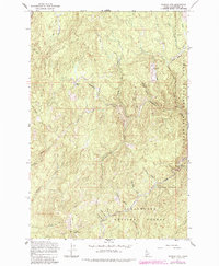
1965 Map of French Mountain
USGS Topo · Published 1967About this map
French Mountain anchors this mid-1960s survey of the Clearwater National Forest, where the landscape is defined by an intricate network of drainages and early mining operations. The map documents the high-country terrain between the Orogrande Creek and French Creek watersheds, highlighting the historical industrial presence at the Oxford Mine and Campbell Mine. These sites, along with the former location of Camp 57, reflect the logging and mineral extraction history of this part of Clearwater National Forest.
Find a feature on this map
32 named features on this map. Tap any name to fly to it.
Don’t see what you’re looking for? This feature index may not catch every label — zoom into the map to look around manually.
Map Details
Editions of this 1965 French Mountain Map
2 editions found
Other maps of this area

1923 · Washington Creek
USGS Topo · 1:125,000

1924 · Weippe
USGS Topo · 1:125,000

1938 · Headquarters
USGS Topo · 1:48,000

1944 · Headquarters
USGS Topo · 1:62,500

1956 · Hamilton
USGS Topo · 1:250,000

1959 · Hamilton
USGS Topo · 1:250,000

1960 · Hamilton
USGS Topo · 1:250,000

1963 · Clarke Mtn
USGS Topo · 1:24,000

1964 · Hamilton
USGS Topo · 1:250,000
1965 · Larch Butte
USGS Topo · 1:24,000