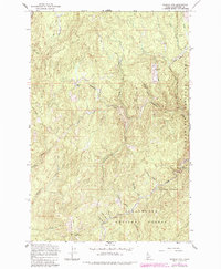
1965 Map of French Mountain
USGS Topo · Published 1984About this map
French Mountain dominates this portion of the Clearwater National Forest, a region defined by steep drainages and early twentieth-century industry. The landscape is carved by a complex network of waterways, including Washington Creek, Orogrande Creek, and South Fork Breakfast Creek. These valleys served as conduits for resource extraction, evidenced by the presence of the Oxford Mine and Campbell Mine. Local history and labor are etched into the terrain at Camp 57 (Site) and through descriptive names like China Gulch and Business Gulch. High-elevation openings like Oxford Meadows and Arnett Meadows Creek contrast with the dense woodland coverage, while primitive transportation is marked by the presence of a Pack Trail and Jeer Trail, indicating the difficulty of navigating this interior timber and mining country before modern road development.
Find a feature on this map
32 named features on this map. Tap any name to fly to it.
Don’t see what you’re looking for? This feature index may not catch every label — zoom into the map to look around manually.
Map Details
Editions of this 1965 French Mountain Map
2 editions found

Other maps of this area

1923 · Washington Creek
USGS Topo · 1:125,000

1924 · Weippe
USGS Topo · 1:125,000

1938 · Headquarters
USGS Topo · 1:48,000

1944 · Headquarters
USGS Topo · 1:62,500

1956 · Hamilton
USGS Topo · 1:250,000

1959 · Hamilton
USGS Topo · 1:250,000

1960 · Hamilton
USGS Topo · 1:250,000

1963 · Clarke Mtn
USGS Topo · 1:24,000

1964 · Hamilton
USGS Topo · 1:250,000
1965 · Larch Butte
USGS Topo · 1:24,000