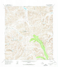
1950 Map of Healy A-4
USGS Topo · Published 1974About this map
Caribou Pass sits at the northern height of this high-altitude landscape, serving as a primary drainage divide in the Matanuska-Susitna region during the mid-twentieth century. The area is defined by a dense network of alpine waterways, with the Jack River and Soule Creek flowing through steep northern valleys while the Tsusena Creek carves a prominent southeast path. The glacial and fluvial geography is further detailed by the East Fork Chulitna River and Portage Creek, showing a wilderness environment largely devoid of established roads or permanent settlements at the time of the 1950 field annotation. This 1:63,360 scale documentation highlights the drainage patterns and unmapped land lines of the Alaska interior before significant modern development reached these remote corridors.
Find a feature on this map
6 named features on this map. Tap any name to fly to it.
Don’t see what you’re looking for? This feature index may not catch every label — zoom into the map to look around manually.
Map Details
Editions of this 1950 Healy A-4 Map
3 editions found
Other maps of this area

1949 · Healy B-4
USGS Topo · 1:63,360

1950 · Talkeetna Mountains
USGS Topo · 1:250,000

1950 · Talkeetna Mountains D-5
USGS Topo · 1:63,360

1950 · Healy A-3
USGS Topo · 1:63,360

1950 · Healy B-3
USGS Topo · 1:63,360

1950 · Healy A-4
USGS Topo · 1:63,360

1950 · Healy A-5
USGS Topo · 1:63,360

1950 · Healy B-5
USGS Topo · 1:63,360

1951 · Healy
USGS Topo · 1:250,000

1951 · Talkeetna Mountains D-5
USGS Topo · 1:63,360