
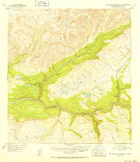
1951 Map of Talkeetna Mountains D-5
USGS Topo · Published 1951About this map
The Susitna River carves through the lower half of this wilderness quadrangle, serving as the primary drainage for a network of glacial and mountain streams. Aerial photography from August 1949 reveals a landscape defined by water and high-elevation terrain, including Thoroughfare Creek and Devil Creek. Evidence of human passage and seasonal habitation is sparse but significant, marked by a Sled Road that traverses the central plateau and several clusters of Cabins or a lone Cabin near the confluence of the river systems. The inclusion of VABM 4741 Portage provides a fixed geodetic reference point amidst the complex topography. This map documents the remote character of the region just before mid-century, where transport was largely dictated by the winter freeze and river corridors like Portage Creek.
Find a feature on this map
9 named features on this map. Tap any name to fly to it.
Don’t see what you’re looking for? This feature index may not catch every label — zoom into the map to look around manually.
Map Details
Editions of this 1951 Talkeetna Mountains D-5 Map
2 editions found
Other maps of this area

1949 · Talkeetna Mountains D-6
USGS Topo · 1:63,360

1949 · Talkeetna Mountains C-6
USGS Topo · 1:63,360

1949 · Healy A-6
USGS Topo · 1:63,360

1950 · Talkeetna Mountains
USGS Topo · 1:250,000

1950 · Talkeetna Mountains D-5
USGS Topo · 1:63,360

1950 · Healy A-4
USGS Topo · 1:63,360

1950 · Healy A-5
USGS Topo · 1:63,360

1950 · Talkeetna Mountains C-5
USGS Topo · 1:63,360

1951 · Healy
USGS Topo · 1:250,000

1951 · Talkeetna Mountains C-4
USGS Topo · 1:63,360