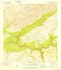
1951 Map of Talkeetna Mountains D-5
USGS Topo · Published 1951About this map
The Susitna River carves a deep valley through this Alaskan landscape, joined by a network of tributaries including Devil Creek and Thoroughfare Creek. At the mid-century, this region remained largely untouched by permanent infrastructure, marked instead by the ephemeral paths of a Sled Road winding through the valley floor. Small outposts such as Cabin and Cabins signify the sparse seasonal or utility-based occupation typical of the area's remote river corridors.
Find a feature on this map
9 named features on this map. Tap any name to fly to it.
Don’t see what you’re looking for? This feature index may not catch every label — zoom into the map to look around manually.
Map Details
Editions of this 1951 Talkeetna Mountains D-5 Map
2 editions found
Other maps of this area

1949 · Talkeetna Mountains D-6
USGS Topo · 1:63,360

1949 · Talkeetna Mountains C-6
USGS Topo · 1:63,360

1949 · Healy A-6
USGS Topo · 1:63,360

1950 · Talkeetna Mountains
USGS Topo · 1:250,000

1950 · Talkeetna Mountains D-5
USGS Topo · 1:63,360

1950 · Healy A-4
USGS Topo · 1:63,360

1950 · Healy A-5
USGS Topo · 1:63,360

1950 · Talkeetna Mountains C-5
USGS Topo · 1:63,360

1951 · Healy
USGS Topo · 1:250,000

1951 · Talkeetna Mountains D-5
USGS Topo · 1:63,360