
1950 Map of Talkeetna Mountains C-5
USGS Topo · Published 1967About this map
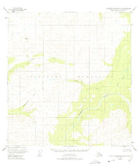
The Talkeetna Mountains define this high-altitude landscape in the Matanuska-Susitna region as it was documented just after the mid-century. The Talkeetna River flows prominently through the lower sections of the sheet, carving a path through the wilderness and receiving several major tributaries. Drainages such as Chunilna Creek, Cache Creek, and Prairie Creek highlight the intricate hydrological network of the area. The map includes the Seward Meridian boundary and landmarks like VABM 4149 Clear, reflecting the early efforts of the Geological Survey to establish vertical control in remote terrain. While there are no roads or trails indicated, the detailed contours and labels like Disappointment Creek reveal the physical challenges encountered by early surveyors and backcountry explorers navigating these high-relief drainage basins.
Find a feature on this map
8 named features on this map. Tap any name to fly to it.
Don’t see what you’re looking for? This feature index may not catch every label — zoom into the map to look around manually.
Map Details
Editions of this 1950 Talkeetna Mountains C-5 Map
2 editions found
Other maps of this area

1949 · Talkeetna Mountains D-6
USGS Topo · 1:63,360

1949 · Talkeetna Mountains B-6
USGS Topo · 1:63,360

1949 · Talkeetna Mountains C-6
USGS Topo · 1:63,360

1950 · Talkeetna Mountains
USGS Topo · 1:250,000

1950 · Talkeetna Mountains B-5
USGS Topo · 1:63,360

1950 · Talkeetna Mountains B-4
USGS Topo · 1:63,360

1950 · Talkeetna Mountains D-5
USGS Topo · 1:63,360

1951 · Talkeetna Mountains D-5
USGS Topo · 1:63,360

1951 · Talkeetna Mountains C-4
USGS Topo · 1:63,360

1951 · Talkeetna Mountains D-6
USGS Topo · 1:63,360