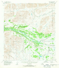
1950 Map of Healy B-3
USGS Topo · Published 1971About this map
The Denali Highway cuts through a remote interior Alaskan landscape in this mid-century survey, providing one of the few terrestrial transit points through the region. The Nenana River dominates the central valley, joined by tributaries such as Wells Creek and Seattle Creek as it winds through the transition from high peaks like Pyramid Pk to the broad expanse of Monahan Flat. The presence of the Landing Strip and Brushkana Campground reflects the era's emerging infrastructure for backcountry access and recreation during the 1950s. Near the southern boundary of the Matanuska-Susitna Borough, the map details a drainage network including the East Fork Jack River and Brushkana Creek, illustrating the complex hydrology of the Alaska Range foothills before major modern development altered these remote corridors.
Find a feature on this map
19 named features on this map. Tap any name to fly to it.
Don’t see what you’re looking for? This feature index may not catch every label — zoom into the map to look around manually.
Map Details
Editions of this 1950 Healy B-3 Map
2 editions found
Other maps of this area

1949 · Healy B-4
USGS Topo · 1:63,360

1949 · Healy C-3
USGS Topo · 1:63,360

1949 · Healy B-2
USGS Topo · 1:63,360

1950 · Healy C-4
USGS Topo · 1:63,360

1950 · Healy A-3
USGS Topo · 1:63,360

1950 · Healy B-3
USGS Topo · 1:63,360

1950 · Healy A-4
USGS Topo · 1:63,360

1951 · Healy
USGS Topo · 1:250,000

1951 · Healy B-4
USGS Topo · 1:63,360

1951 · Healy C-2
USGS Topo · 1:63,360