
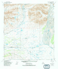
1949 Map of Healy B-2
USGS Topo · Published 1965About this map
Monahan Flat dominates this 1949 topographic landscape, forming a broad expanse between the glacial waters of the Nenana River and the West Fork Susitna River. The survey depicts a watershed in transition, where high mountain peaks give way to the braided stream networks of Canyon Creek and Wells Creek. This mid-century study reflects the raw interior of the Matanuska-Susitna Borough prior to significant infrastructure development, capturing the intricate drainage patterns of Siksik Lake and Thief Creek. The presence of the Fairbanks Meridian underscores the systematic mapping effort required to document these unsurveyed and unmarked land lines, which were predetermined by the Bureau of Land Management through photogrammetric methods.
Find a feature on this map
9 named features on this map. Tap any name to fly to it.
Don’t see what you’re looking for? This feature index may not catch every label — zoom into the map to look around manually.
Map Details
Editions of this 1949 Healy B-2 Map
2 editions found
Other maps of this area

1949 · Healy C-3
USGS Topo · 1:63,360

1949 · Healy A-1
USGS Topo · 1:63,360

1950 · Healy A-3
USGS Topo · 1:63,360

1950 · Healy B-3
USGS Topo · 1:63,360

1950 · Healy B-1
USGS Topo · 1:63,360

1951 · Healy
USGS Topo · 1:250,000

1951 · Healy C-1
USGS Topo · 1:63,360

1951 · Healy C-2
USGS Topo · 1:63,360

1951 · Healy A-2
USGS Topo · 1:63,360
1952 · Healy A-1
USGS Topo · 1:63,360