
1951 Map of Healy C-2
USGS Topo · Published 1961About this map
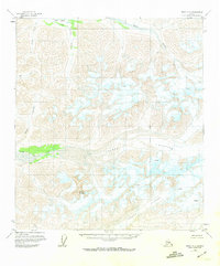
The Nenana Glacier dominates the southeastern quadrant of this mid-century Alaskan landscape, its massive ice field marked by numerous crevasses that indicate the slow, powerful movement of the glacier. To the west, the ice gives way to the prominent peak of Nenana Mountain, while the glacial meltwater feeds into the braided channels of the Yanert Fork. This environment is defined by its drainages, with the Wood River collecting waters from tributaries like Big Grizzly Creek and Young Creek in the north. The absence of roads or established settlements, coupled with the reliance on photogrammetric methods from 1950 and 1954 aerial surveys, highlights the difficulty of mapping this interior region. The Fairbanks Meridian serves as the primary longitudinal reference for these unsurveyed lands, where watercourses like Dick Creek and Edgar Creek provide the only named landmarks across the high-altitude terrain.
Find a feature on this map
11 named features on this map. Tap any name to fly to it.
Don’t see what you’re looking for? This feature index may not catch every label — zoom into the map to look around manually.
Map Details
Editions of this 1951 Healy C-2 Map
2 editions found
Other maps of this area

1949 · Healy C-3
USGS Topo · 1:63,360

1949 · Healy B-2
USGS Topo · 1:63,360

1949 · Healy D-1
USGS Topo · 1:63,360

1950 · Healy B-3
USGS Topo · 1:63,360

1950 · Healy B-1
USGS Topo · 1:63,360

1950 · Healy D-3
USGS Topo · 1:63,360

1951 · Healy
USGS Topo · 1:250,000

1951 · Healy C-1
USGS Topo · 1:63,360
1951 · Healy D-2
USGS Topo · 1:63,360
1952 · Healy D-1
USGS Topo · 1:63,360