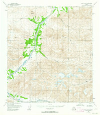
1951 Map of Healy D-2
USGS Topo · Published 1964About this map
Wood River cuts a prominent north-south path through this 1951 interior Alaska landscape, providing the primary drainage for numerous glacial and mountain tributaries. The terrain is defined by high peaks such as Mystic Mountain and deep topographic features like the Canyon in the west and Grizzly in the southwest. A lone Cabin situated along the riverbanks represents the only human structural footprint in this expansive wilderness, which was surveyed by the Geological Survey via photogrammetric methods from 1949 aerial photography.
Find a feature on this map
17 named features on this map. Tap any name to fly to it.
Don’t see what you’re looking for? This feature index may not catch every label — zoom into the map to look around manually.
Map Details
Editions of this 1951 Healy D-2 Map
2 editions found
Other maps of this area

1949 · Healy C-3
USGS Topo · 1:63,360

1949 · Fairbanks A-2
USGS Topo · 1:63,360

1949 · Fairbanks A-1
USGS Topo · 1:63,360

1949 · Healy D-1
USGS Topo · 1:63,360

1950 · Fairbanks
USGS Topo · 1:250,000

1950 · Fairbanks A-3
USGS Topo · 1:63,360

1950 · Healy D-3
USGS Topo · 1:63,360

1951 · Healy
USGS Topo · 1:250,000

1951 · Fairbanks
USGS Topo · 1:250,000

1951 · Healy C-1
USGS Topo · 1:63,360