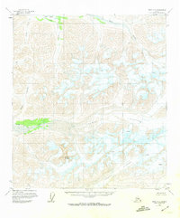
1951 Map of Healy C-2
USGS Topo · Published 1973About this map
Yanert Glacier and the expansive Nenana Glacier dominate this subarctic landscape, carving deep valleys through the rugged interior. Mapped from 1950s aerial photography with 1970s revisions, the sheet captures a wilderness defined by massive ice fields and high peaks, including Nenana Mountain. The drainage systems here are complex, with the Yanert Fork and the Wood River carrying glacial runoff across a terrain marked by numerous crevasses and alpine streams like Big Grizzly Creek and Edgar Creek. This area sits along the Fairbanks Meridian, representing a region entirely devoid of established roads or trails at the time of the survey. The topography illustrates the powerful erosive force of these glaciers, providing a detailed look at the unpopulated northern reaches of the Alaska Range before modern developments reached deeper into the interior.
Find a feature on this map
12 named features on this map. Tap any name to fly to it.
Don’t see what you’re looking for? This feature index may not catch every label — zoom into the map to look around manually.
Map Details
Editions of this 1951 Healy C-2 Map
2 editions found
Other maps of this area

1949 · Healy C-3
USGS Topo · 1:63,360

1949 · Healy B-2
USGS Topo · 1:63,360

1949 · Healy D-1
USGS Topo · 1:63,360

1950 · Healy B-3
USGS Topo · 1:63,360

1950 · Healy B-1
USGS Topo · 1:63,360

1950 · Healy D-3
USGS Topo · 1:63,360

1951 · Healy
USGS Topo · 1:250,000

1951 · Healy C-1
USGS Topo · 1:63,360

1951 · Healy C-2
USGS Topo · 1:63,360
1951 · Healy D-2
USGS Topo · 1:63,360