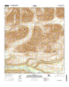
2016 Map of Healy B-3 NW
USGS Topo · Published 2016About this map
McKinley Park land dominates the northwestern corner of this 2016 survey, where the high subarctic terrain begins its ascent toward the Alaska Range. The southern portion of the map is defined by the glacial waters of the Nenana River, which flows alongside the critical corridor of the Denali Highway. This route remains one of the few ways to traverse this interior landscape, following the river valley through the mountain passes. High points such as Pyramid Peak stand as prominent landmarks above the drainage basins of Bruskasna Cr and Wells Cr. The map illustrates a landscape of extreme topography and minimal human infrastructure, emphasizing the importance of the single highway as the lifeline for transport and access in the Denali Borough.
Find a feature on this map
12 named features on this map. Tap any name to fly to it.
Don’t see what you’re looking for? This feature index may not catch every label — zoom into the map to look around manually.
Map Details
Editions of this 2016 Healy B-3 NW Map
This is the sole edition of this map. No revisions or reprints were ever made.
Other maps of this area

1949 · Healy B-4
USGS Topo · 1:63,360

1949 · Healy C-3
USGS Topo · 1:63,360

1950 · Healy C-4
USGS Topo · 1:63,360

1950 · Healy B-3
USGS Topo · 1:63,360

1951 · Healy
USGS Topo · 1:250,000

1951 · Healy B-4
USGS Topo · 1:63,360
1952 · Healy C-4
USGS Topo · 1:63,360
1952 · Healy B-3
USGS Topo · 1:63,360
1952 · Healy C-3
USGS Topo · 1:63,360

1956 · Healy
USGS Topo · 1:250,000