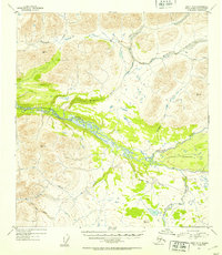
1952 Map of Healy B-3
USGS Topo · Published 1953About this map
The Nenana River carves a central path through this Alaskan interior landscape, its braided channels flanked by expansive green-shaded vegetation zones. To the southeast, the broad expanse of Monahan Flat indicates the characteristic level terrain of the region, while the surrounding area is defined by a dense network of high-altitude drainages. Significant waterways include Wells Creek, Seattle Creek, and the East Fork Jack River, which feed into the primary river system.
Find a feature on this map
14 named features on this map. Tap any name to fly to it.
Don’t see what you’re looking for? This feature index may not catch every label — zoom into the map to look around manually.
Map Details
Editions of this 1952 Healy B-3 Map
2 editions found
Other maps of this area

1949 · Healy B-4
USGS Topo · 1:63,360

1949 · Healy C-3
USGS Topo · 1:63,360

1949 · Healy B-2
USGS Topo · 1:63,360

1950 · Healy C-4
USGS Topo · 1:63,360

1950 · Healy A-3
USGS Topo · 1:63,360

1950 · Healy B-3
USGS Topo · 1:63,360

1950 · Healy A-4
USGS Topo · 1:63,360

1951 · Healy
USGS Topo · 1:250,000

1951 · Healy B-4
USGS Topo · 1:63,360

1951 · Healy C-2
USGS Topo · 1:63,360