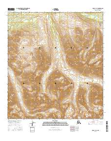
2016 Map of Healy C-4 SE
USGS Topo · Published 2016About this map
Alaska Range peaks and high mountain drainage basins define this interior wilderness during the early twenty-first century. This portion of McKinley Park is characterized by its significant elevation changes and glacial-carved topography, long before modern infrastructure would alter these remote corridors. The landscape is primarily defined by its hydrology, with steep-banked watercourses like Revine Cr, Moose Cr, and Carlo Cr cutting through the high country. As a snapshot of the Denali region, the map illustrates the complex township and range system overlaying the wilderness, marking out t15s r6w and t16s r6w across the mountain slopes. The lack of roads or established trails highlights the preserved state of the terrain, offering a clear view of the natural drainage patterns that have shaped the subarctic environment for millennia.
Find a feature on this map
9 named features on this map. Tap any name to fly to it.
Don’t see what you’re looking for? This feature index may not catch every label — zoom into the map to look around manually.
Map Details
Editions of this 2016 Healy C-4 SE Map
This is the sole edition of this map. No revisions or reprints were ever made.
Other maps of this area

1949 · Healy B-4
USGS Topo · 1:63,360

1949 · Healy C-3
USGS Topo · 1:63,360

1950 · Healy C-4
USGS Topo · 1:63,360

1950 · Healy B-3
USGS Topo · 1:63,360

1951 · Healy
USGS Topo · 1:250,000

1951 · Healy B-4
USGS Topo · 1:63,360
1952 · Healy C-4
USGS Topo · 1:63,360
1952 · Healy B-3
USGS Topo · 1:63,360
1952 · Healy C-3
USGS Topo · 1:63,360

1956 · Healy
USGS Topo · 1:250,000