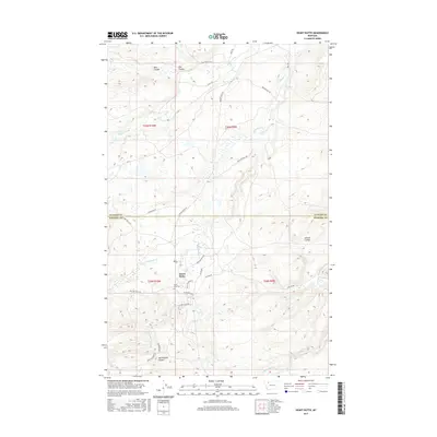
2017 Map of Heart Butte
USGS Topo · Published 2017About this map
Heart Butte serves as the focal point of this modern survey at the edge of the Rockies, where the Glacier Co Pondera Co line bisects the high plains. The landscape is defined by an intricate network of waterways and drainage features, including the Badger Creek valley and various coulees such as Bite Coulee and Tail Feather Coulee. To the south, the Swift Reservoir and Fish Lake provide significant water management landmarks in an area dominated by local ranching and road systems like Tatsey Rd and New Dayrider Rd.
Find a feature on this map
40 named features on this map. Tap any name to fly to it.
Don’t see what you’re looking for? This feature index may not catch every label — zoom into the map to look around manually.
Map Details
Editions of this 2017 Heart Butte Map
This is the sole edition of this map. No revisions or reprints were ever made.
Other maps of this area

1914 · Heart Butte
USGS Topo · 1:125,000

1918 · Heart Butte
USGS Topo · 1:125,000

1960 · Cut Bank
USGS Topo · 1:250,000

1963 · Cut Bank
USGS Topo · 1:250,000

1964 · Cut Bank
USGS Topo · 1:250,000

1968 · Swift Reservoir
USGS Topo · 1:24,000
1968 · Piegan
USGS Topo · 1:24,000

1968 · Fish Lake
USGS Topo · 1:24,000

1968 · White Man Coulee
USGS Topo · 1:24,000
1968 · Magee Ranch
USGS Topo · 1:24,000