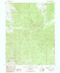
1990 Map of Heath Canyon
USGS Topo · Published 1990About this map
The Grant Range dominates this portion of the Humboldt National Forest, where the terrain is marked by high mountain passes and seasonal water sources. Reaching back to data from the early 1960s with updates through 1990, the map illustrates a landscape accessible primarily by 4wd tracks and a Pack Trail winding through the high country. Historical mining activity is noted by a cluster of prospects near Sawmill Pass, while livestock and wildlife rely on scattered water points like Heath Springs and Balsam Spring. The drainage patterns are clearly defined by steep-walled corridors such as Heath Canyon and Grant Canyon, which feed into the wider Big Spring Wash below. This survey captures the remote character of the Nevada interior, where land use was defined by forest management and the search for minerals.
Find a feature on this map
21 named features on this map. Tap any name to fly to it.
Don’t see what you’re looking for? This feature index may not catch every label — zoom into the map to look around manually.
Map Details
Editions of this 1990 Heath Canyon Map
This is the sole edition of this map. No revisions or reprints were ever made.
Other maps of this area

1956 · Lund
USGS Topo · 1:250,000

1960 · Lund
USGS Topo · 1:250,000

1964 · Blue Eagle Springs
USGS Topo · 1:62,500

1964 · Currant
USGS Topo · 1:62,500

1964 · Troy Canyon
USGS Topo · 1:62,500

1964 · Forest Home
USGS Topo · 1:62,500

1980 · Duckwater
USGS Topo · 1:100,000

1988 · Quinn Canyon Range
USGS Topo · 1:100,000
1990 · Troy Canyon
USGS Topo · 1:24,000
1990 · Wells Station
USGS Topo · 1:24,000