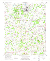
1978 Map of Heath
USGS Topo · Published 1978About this map
The Old Kentucky Ordnance Works and the expansive Paducah Plant dominate the landscape west of Paducah in the late 1970s. This industrial and military footprint sits alongside the West Kentucky State Wildlife Management Area, illustrating a complex mid-century transition from wartime production to energy research and conservation. The rural character of McCracken and Ballard counties remains evident in the network of small settlements like Cimota City, Heath, and Grahamville.
Find a feature on this map
69 named features on this map. Tap any name to fly to it.
Don’t see what you’re looking for? This feature index may not catch every label — zoom into the map to look around manually.
Map Details
Editions of this 1978 Heath Map
This is the sole edition of this map. No revisions or reprints were ever made.
Other maps of this area

1926 · Paducah
USGS Topo · 1:62,500

1928 · La Center
USGS Topo · 1:62,500

1929 · Paducah
USGS Topo · 1:62,500

1932 · La Center
USGS Topo · 1:62,500

1936 · Melber
USGS Topo · 1:24,000

1940 · Paducah
USGS Topo · 1:62,500

1949 · Paducah
USGS Topo · 1:250,000

1950 · Paducah
USGS Topo · 1:250,000

1951 · Blandville
USGS Topo · 1:24,000

1951 · Melber
USGS Topo · 1:24,000