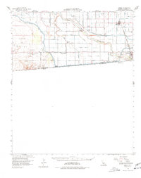
1957 Map of Heber
USGS Topo · Published 1977About this map
The All American Canal and the New River define this arid borderland, where a dense network of irrigation channels like the Beech Canal and Dahlia Canal transformed the desert into a productive agricultural zone. Along the international boundary, Calexico serves as the primary hub, showing early infrastructure such as the Calexico Airport, a Border Patrol Observation Tower, and the Southern Pacific railroad line.
Find a feature on this map
59 named features on this map. Tap any name to fly to it.
Don’t see what you’re looking for? This feature index may not catch every label — zoom into the map to look around manually.
Map Details
Editions of this 1957 Heber Map
2 editions found
Other maps of this area

1907 · Holtville
USGS Topo · 1:125,000

1915 · El Centro
USGS Topo · 1:125,000

1940 · Brawley
USGS Topo · 1:62,500

1940 · Heber
USGS Topo · 1:62,500

1940 · Plaster City
USGS Topo · 1:62,500

1940 · Alamorio
USGS Topo · 1:62,500

1940 · Coyote Wells
USGS Topo · 1:62,500

1940 · Calexico
USGS Topo · 1:62,500

1942 · El Centro
USGS Topo · 1:250,000

1943 · Coyote Wells
USGS Topo · 1:62,500