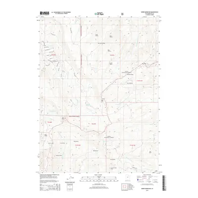
2014 Map of Heber Mountain
USGS Topo · Published 2014About this map
The high ridges of the Uinta National Forest dominate this 2014 survey, where the drainages of the Little S Fork Provo River and the Strawberry River diverge. The landscape is defined by its water management and diverse topographic landmarks, from the elevation of Heber Mtn and Currant Creek Peak to the essential catchments of the Dee Mills Reservoir and Center Cr Number Five Reservoir. This portion of Wasatch County shows a transition from the structured residential roads of the northwest corner, such as Lake Creek Rd and Tanglewood Dr, into the deep basins and canyons of the backcountry. Geographers can trace the intricate network of hollows, including Buck Hollow and Dip Vat Hollow, which feed into the regional river systems that sustain the valley below.
Find a feature on this map
59 named features on this map. Tap any name to fly to it.
Don’t see what you’re looking for? This feature index may not catch every label — zoom into the map to look around manually.
Map Details
Editions of this 2014 Heber Mountain Map
This is the sole edition of this map. No revisions or reprints were ever made.
Other maps of this area

1885 · Salt Lake
USGS Topo · 1:250,000

1900 · Coalville
USGS Topo · 1:125,000

1903 · Coalville
USGS Topo · 1:125,000

1907 · Strawberry Valley
USGS Topo · 1:125,000

1909 · Strawberry Valley
USGS Topo · 1:125,000

1954 · Salt Lake City
USGS Topo · 1:250,000

1958 · Salt Lake City
USGS Topo · 1:250,000

1960 · Salt Lake City
USGS Topo · 1:250,000

1967 · Francis
USGS Topo · 1:24,000
1967 · Center Creek
USGS Topo · 1:24,000