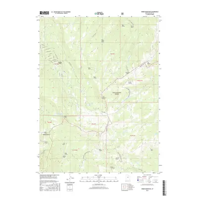
2017 Map of Heber Mountain
USGS Topo · Published 2017About this map
Timber Lakes occupies the northwestern corner of this mountain terrain, characterized by a dense residential street network including Birch Rd, Aspen Rd, and Marigold Ln. This high-altitude settlement pattern transitions sharply into the Uinta National Forest, where the landscape is defined by massive ridges and deep drainage systems. Heber Mountain stands as a central topographic anchor, flanked by the Duchesne Ridge and the headwaters of several major waterways, including the Strawberry River and Currant Creek. Water management is visible through features like the Dee Mills Reservoir and Center Creek Number Five Reservoir. The eastern and southern portions of the map reveal a landscape shaped by glacial and fluvial erosion, with numerous named hollows such as Bellows Hollow and Bear Hollow providing a complex network of natural basins. Local recreation and access are facilitated by the Little S Fork Trail and the Roundy Basin/West Side Straw route, which navigate the high peaks and meadows.
Find a feature on this map
62 named features on this map. Tap any name to fly to it.
Don’t see what you’re looking for? This feature index may not catch every label — zoom into the map to look around manually.
Map Details
Editions of this 2017 Heber Mountain Map
This is the sole edition of this map. No revisions or reprints were ever made.
Other maps of this area

1885 · Salt Lake
USGS Topo · 1:250,000

1900 · Coalville
USGS Topo · 1:125,000

1903 · Coalville
USGS Topo · 1:125,000

1907 · Strawberry Valley
USGS Topo · 1:125,000

1909 · Strawberry Valley
USGS Topo · 1:125,000

1954 · Salt Lake City
USGS Topo · 1:250,000

1958 · Salt Lake City
USGS Topo · 1:250,000

1960 · Salt Lake City
USGS Topo · 1:250,000

1967 · Francis
USGS Topo · 1:24,000
1967 · Center Creek
USGS Topo · 1:24,000