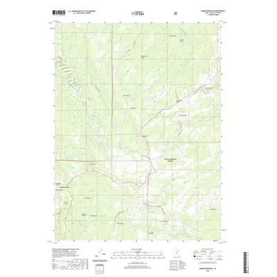
2020 Map of Heber Mountain
USGS Topo · Published 2020About this map
Independence sits at the western edge of this High Uintas landscape, where residential development like Blue Spruce Dr and Columbine Ln meets the vast wilderness of the Uinta National Forest. The map documents a critical hydrologic divide at the summit of Heber Mtn, where headwaters flow toward disparate systems, including the Strawberry River and the Little S Fork Provo River. Significant water management is evident through features such as the Center Cr Number Five Reservoir and Dee Mills Reservoir, which support the high-altitude ecosystem.
Find a feature on this map
57 named features on this map. Tap any name to fly to it.
Don’t see what you’re looking for? This feature index may not catch every label — zoom into the map to look around manually.
Map Details
Editions of this 2020 Heber Mountain Map
This is the sole edition of this map. No revisions or reprints were ever made.
Other maps of this area

1885 · Salt Lake
USGS Topo · 1:250,000

1900 · Coalville
USGS Topo · 1:125,000

1903 · Coalville
USGS Topo · 1:125,000

1907 · Strawberry Valley
USGS Topo · 1:125,000

1909 · Strawberry Valley
USGS Topo · 1:125,000

1954 · Salt Lake City
USGS Topo · 1:250,000

1958 · Salt Lake City
USGS Topo · 1:250,000

1960 · Salt Lake City
USGS Topo · 1:250,000

1967 · Francis
USGS Topo · 1:24,000
1967 · Center Creek
USGS Topo · 1:24,000