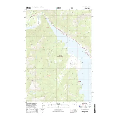
2017 Map of Hebgen Dam
USGS Topo · Published 2017About this map
The Hebgen Dam controls the flow of the Madison River in this high-altitude Montana landscape, where the waters of Hebgen Lake and Hebgen Reservoir dominate the eastern topography. The presence of Ghost Village Rd and Earthquake Lake alludes to the seismic history of this region within the Gallatin National Forest. To the south and west, the terrain rises sharply toward the Continental Divide, marked by prominent landmarks such as Coffin Mtn and the adjacent Coffin Lake and Upper Coffin Lake. The map details a complex network of alpine drainage, including Watkins Cr and Kirkwood Cr, alongside established routes like Hebgen Lake Rd and Firehole Ranch Rd that navigate the ridges and shorelines.
Find a feature on this map
35 named features on this map. Tap any name to fly to it.
Don’t see what you’re looking for? This feature index may not catch every label — zoom into the map to look around manually.
Map Details
Editions of this 2017 Hebgen Dam Map
This is the sole edition of this map. No revisions or reprints were ever made.
Other maps of this area

1950 · Hebgen Dam
USGS Topo · 1:62,500

1955 · Ashton
USGS Topo · 1:250,000

1958 · Ashton
USGS Topo · 1:250,000

1958 · West Yellowstone
USGS Topo · 1:62,500
1958 · Tepee Creek
USGS Topo · 1:62,500

1960 · Ashton
USGS Topo · 1:250,000

1964 · Targhee Pass
USGS Topo · 1:24,000

1964 · Targhee Peak
USGS Topo · 1:24,000

1964 · Henrys Lake
USGS Topo · 1:62,500
1986 · Madison Arm
USGS Topo · 1:24,000